


A Dedication to Cooperation
The Nez Perce, Umatilla, Warm Springs and Yakama tribes and the federal, state and private entities involved in the management and protection of Columbia Basin fish, water and habitat resources have found that resolving their differences outside formal dispute resolution processes is usually more productive. Each of the four tribes has numerous examples that demonstrate how much more can be accomplished by working together. Here are four such stories.
Co-ownership was alternative to conflict over FERC license
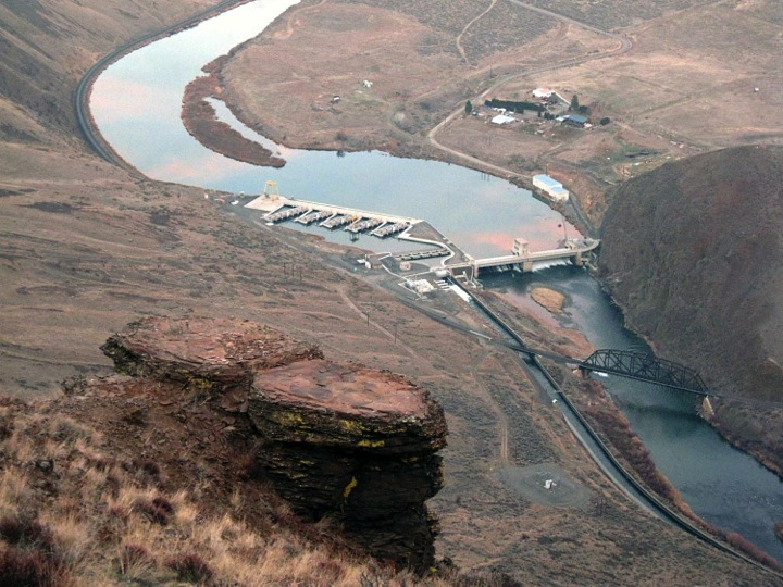
The Confederated Tribes of the Warm Springs of Oregon announced in 1995 that it would compete for a license from the Federal Energy Regulatory Commission (FERC) to operate the Pelton Round Butte hydroelectric project on the Deschutes River.
Part of the tribe’s central Oregon homelands, the Deschutes River is the source of irrigation, electricity, habitat for salmon and other benefits.
In 1964 Portland General Electric (PGE) completed construction of the three-dam Pelton Round Butte hydroelectric project on the Deschutes. Within a few years, anadromous (ocean-going) spring chinook, steelhead, sockeye and lamprey were gone from over 200 miles of habitat above the dams.
Fast forward to 2012. The Warm Springs tribe is now one-third owner of the Pelton Round Butte complex, and for the first time in 40 years sockeye, spring chinook and steelhead are returning, albeit in small numbers, to the upper Deschutes basin.
What changed? In 2000 over 20 agencies, local governments and citizen organizations signed a settlement agreement, allowing FERC to grant a co-license to PGE and the Warm Springs tribe. The tribe became an owner in the complex and can hold a controlling interest as early as 2029.
The parties and FERC decided that to operate the dams, the co-licensees would need to take certain measures to return fish passage, reconnect the lower and upper Deschutes Basin, restore habitat and fund acquisition of water rights and lands among other actions.
OPERATING PELTON ROUND BUTTE HYDROELECTRIC DAMS FOR FISH

Working with the Forest Service
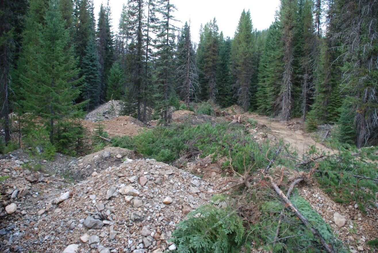
The Nez Perce Tribe has always considered Newsome Creek watershed a sacred place. This tributary stream of the South Fork Clearwater River in Idaho had abundant chinook and steelhead runs. But nearly 30 years of dredge mining beginning in the late 1930s devastated the stream channel and floodplain, destroying fish runs.
During this multi-year project, the Nez Perce Tribe Department of Fisheries Resource Management, Watershed Division, in cooperation with the Bonneville Power Administration and the Nez Perce-Clearwater National Forests removed 10,000 cubic yards of mine tailings to reconnect floodplain and stream channel processes and returned large woody debris and boulders to the stream. New side channels and meander bends were also constructed to provide more rearing habitat for salmonids.
Two more phases of stream and floodplain restoration are slated for implementation in 2014 and 2015, including replanting several miles of riparian vegetation.
This is one of the numerous collaborative watershed projects of the Nez Perce Tribe and the U.S. Forest Service National Forests. The tribe’s work has received the U.S. Forest Service Regional Forester Award for Restoration Partnership and the U.S. Department of Agriculture Forest Service Rise of the Future Award.
DREDGE MINING DESTROYED NEWSOME CREEK AND ITS FISH
Water Management Consensus Avoids Costly Litigation
Demand for water in the Yakima Basin currently outstrips supply. With population growth and climate change, the strain on water supplies will only intensify. Water battles in the Yakima Basin, however, are not as likely since the Yakama Nation, irrigation districts and others agreed to an integrated water management plan.
After years of conflict and litigation, representatives of over 40 government and non-government entities sat together and developed the Yakima Basin Integrated Water Management Plan. In 2012, after three years of work, they achieved consensus on a strategy to have adequate water supplies for instream flow, irrigation and municipal uses.
The strategy marries water resource management and ecosystem restoration by:
- Creating additional groundwater and surface storage capacity.
- Establishing reservoir fish passage.
- Modifying water system operation and infrastructure.
- Implementing additional water conservation projects.
- Enhancing and protecting habitat and increasing instream flows.
- Employing water marketing and banking.
Historically, the Yakima Basin, which is part of the Yakama Nation ceded area, produced over 800,000 chinook, sockeye, coho, steelhead and lamprey. In recent years, the run size averages about 20,000 anadromous fish. Implementation of the water plan will aid fish recovery.
POPULATION GROWTH AND CLIMATE CHANGE ADD TO WATER CHALLENGES
Funders and Landowners Play Important Role
The Confederated Tribes of the Umatilla Indian Reservation (CTUIR) demonstrated what could be done to return floodplain and instream function to a river with the support of funders and landowners as partners.
Meacham Creek’s natural aquatic abundance began changing over 100 years ago when farmers and ranchers constructed dikes, cut and cleared trees, and grazed cattle in riverine areas. Union Pacific Railroad laid tracks along the river and built a half-mile of levees to protect the railroad bed from floods. These and other activities degraded some 14 miles of Meacham Creek. Its spring chinook, steelhead and bull trout were listed under the Endangered Species Act.
Tribal members—grandparents and great-grandparents now—remember fishing, camping, and swimming in Meacham Creek and want their grandchildren and the generations yet to come to enjoy the same experiences.
Using historical photos and laser imaging, tribal crews rebuilt the meandering stream channel and reconfigured side-channels and a wider floodplain. On the 1.2-mile stretch of creek, a series of railroad levees were also removed, giving the creek access to the floodplain.
Eric Quaempts, director the CTUIR’s natural resource department, told the tribal newspaper that trees and shrubs were thought to cool streams by providing shade. “While shade is important, the driving factor is the connections between surface and ground waters. Now the water will flow into the floodplain and be absorbed into the gravel and rocks and then return back to the creek as cool water.”
CTUIR’s Meacham Creek work, which is within the boundaries of the Umatilla reservation, is expected to protect 176 square miles of watershed. Funding for the project came from Bonneville Power Administration through the Columbia River Fish Accords, with help from Oregon Watershed Enhancement Board, Pacific Coastal Salmon Recovery Fund, U.S. Forest Service-Challenge Cost Share Grant and Blue Mountain Habitat Restoration.
MEACHAM CREEK RESTORATION
