


Tucannon River
The Tucannon Subbasin encompasses 503 square miles in Garfield and Columbia counties drained by the Tucannon River and its tributaries. Pataha Creek is the Tucannon’s major tributary. The Tucannon arises in the Blue Mountains and enters the Snake River at River Mile 62.2 near the mouth of the Palouse River. The area has an average annual rainfall of 23 inches which includes winter snowfall. Melting snow from the Blue Mountains provides much of the annual runoff to the streams and rivers in the subbasin; the water level in many streams diminishes greatly during the summer months. Vegetation in the subbasin is characterized by grasslands and agricultural lands at lower elevations and evergreen forests at higher elevations.
Major land uses in the subbasin are related to agriculture; cropland, forest, rangeland, pasture, and hay production account for more than 90 percent of the land within the watershed. Approximately 75 percent of the Tucannon subbasin is in private ownership; most of this land is in the lower portion of the watershed.
The planning process in the Tucannon subbasin involved a number of organizations, agencies, and interested parties including the Columbia Conservation District, Nez Perce Tribe, Confederated Tribes of the Umatilla Indian Reservation, Washington Department of Fish and Wildlife, private landowners and others. The lead entity for the planning effort was the Columbia Conservation District with the Nez Perce Tribe and Confederated Tribes of the Umatilla Indian Reservation as the co-leads. The technical components of the assessment were developed by the Washington Department of Fish and Wildlife. The planning effort was guided by the Asotin, Lower Snake, and Tucannon Subbasin Planning Team which included representation from the lead entity, co-leads, local resource managers, conservation districts, agencies, private landowners, and other interested parties. The vision statement and guiding principles for the management plan were formulated by the Subbasin Planning Team through a collaborative and public process. The vision statement is as follows.
The vision for the Tucannon Subbasin is a healthy ecosystem with abundant, productive, and diverse populations of aquatic and terrestrial species that supports the social, cultural and economic well-being of the communities within the Subbasin and the Pacific Northwest.
Together with the guiding principles, the vision statement provided guidance regarding the assumptions and trade-offs inherent in natural resource planning.
Aquatic Focal Species and Species of Interest
To guide the assessment and management plan, focal species were selected for aquatic and terrestrial habitats within the Tucannon Subbasin. Aquatic focal species are steelhead/rainbow trout, spring Chinook and fall Chinook salmon, and bull trout. In addition, Pacific lamprey, coho salmon, freshwater mussels, and mountain whitefish were designated as aquatic “species of interest” for this planning effort. These species are of cultural and ecological significance to stakeholders, but not enough information was available to warrant their selection as focal species.
Aquatic Habitat Assessment
For Tucannon River summer steelhead and spring/fall Chinook salmon, the EDT analysis identified areas that currently have high production and should be protected (High Protection Value) and areas with the greatest potential for restoring life stages critical to increasing production (High Restoration Value). These initial EDT results were then reviewed in light of the following four considerations: 1) results of related assessment and planning documents (Limiting Factors Analysis, Tucannon Subbasin Summary, Tucannon Model Watershed Plan, etc.); 2) the necessary trade-offs between the biological benefits provided by enhancement potential of one geographic area versus another to achieve geographic prioritization; 3) balancing the needs of all aquatic focal species; and 4) physical and socioeconomic limitations. This type of review was necessary given the data gaps currently present in the EDT model and the fact that EDT is an ecologically-based model that does not incorporate factors such as limited access to wilderness areas. Through this review, the initial EDT results were modified in a limited number of instances to develop a group of priority restoration geographic areas and a group of priority protection geographic areas. These geographic areas include the stream reaches themselves and the upland areas that drain to these reaches.
The areas with the highest restoration value in the Tucannon Subbasin are: Tucannon River from Pataha-Marengo, Tucannon River from Marengo-Tumalum, Tucannon River from Tumalum-Hatchery,Tucannon River from Hatchery-Little Tucannon, and Mountain Tucannon. Within these priority areas, the most negatively impacted life stages were identified for steelhead and spring Chinook. In each of these areas, the key environmental factors that contribute to losses in focal species performance, i.e. limiting factors, were also identified. Key limiting factors for steelhead and spring/fall Chinook included the following: sediment, large woody debris, key habitat (pools), riparian function, stream confinement, summer water temperature, and flow. Decreasing the effect of these limiting factors through habitat enhancement is expected to benefit bull trout as well as steelhead, spring Chinook, and fall Chinook.
Priority protection geographic areas for aquatic focal species include the five areas identified for restoration plus Panjab Creek, Cummings Creek, the lower Tucannon River, and the Tucannon River headwaters. Protecting current habitat conditions in these geographic areas is expected to achieve no loss of function, and to allow for natural attenuation of limiting factors over time to benefit aquatic habitat.
Subbasin Plan Download
![]() Subbasin plans are stored on the Northwest Power and Conservation Council’s website. All links will open on their website.
Subbasin plans are stored on the Northwest Power and Conservation Council’s website. All links will open on their website.
Tucannon River Subbasin Plan (6.7 MB PDF)
Click here to go to the plan materials overview page.
Tucannon River Subbasin

Tucannon River Subbasin
Scenes from the Subbasin
Scenes from the Subbasin
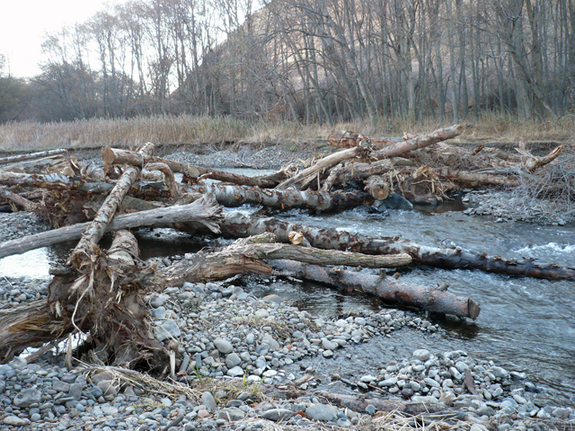
Tucannon River instream habitat enhancement. Photo: Columbia Conservation District